Showing posts with label origins. Show all posts

Saturday, June 27, 2015

Melbourne's Indigenous Placenames

Melbourne's European history is short.

The first explorers began surveying the coast in the 17th century, and the first short lived settlement was attempted at Sorrento in 1803. A more permanent township was established by ambitious pastoralists in 1835.

As a city, we haven't even reached our bicentenary.

But human occupation of what became Port Phillip Bay stretches back much farther back than this.


The five Nations that make up the Kulin Nation.

Melbourne's Indigenous population established itself in the area between 31 000 and 40 000 years ago. By the time the first European settlers arrived, the land around Port Phillip Bay was home to five individual Indigenous Nations, who peacefully co-existed under the banner of the Kulin Nation. Each of these Nations had their own language and traditions, although there was some overlap between their cultural traits.

The arrival of farmers, merchants and soldiers would change the local Indigenous way of life forever. But, as a small  reminder that local history did not start in 1835, our modern city is still dotted with a number of Indigenous place names. A short selection of these:


Bulleen

This suburb in Melbourne's inner east can trace the route of its name to the Bolin Bolin Billabong, a key watering hole for the area's original Indigenous inhabitants. The Billabong is still in existance, now lying in... Bulleen Park,


Bundoora

Bundoora is an Indigenous word, normally translated as 'Place where kangaroos live.'


Carrum/Carrum Downs

The name Carrum is linked to the Indigenous word 'Karrum', a the local name for a boomerang.


The Eastern Brown Snake, common in Melbourne's outskirts.

Coolaroo

North of the CBD, the suburb of Coolaro takes its name for the local Indigenous word for a brown snake.


Dandenong

All the different iterations of Dandenong (suburb, mountain, shire council) can be traced to the Wurundjeri word 'Tanjenong', which was the local name for the creek that ran out of the ranges towards the Yarra.


The Welcome Swallow, one of several species common in Melbourne.

Darebin

This shire council in Melbourne's inner north takes its name from the Indigenous word for 'Swallows', a common bird in the area.


Koo Wee Rup

On the southern outskirts of the city, Koo Wee Rup is derived from the Indigenous name for this area Kowe Nerup; Kowe, meaning blackfish, and Nerup meaning swimming. So this was a swampy area, and a traditional fishing ground for the area's first inhabitants.


Kooyong

Blue blood suburb Kooyong was named by Government surveyor Robert Hoddle after the Kooyong Koot Creek (now Gardiner's Creek). Kooyong is an Indiegnous word meaning camp, or resting place.


Maribyrnong

This inner city suburb is named after it's dominant feature; the Maribyrnong River, which was originally dubbed 'Saltwater Creek' by the first European Settlers. The Indigenous name for the river is Mirring-Gnay-Bir-Nong, which was adopted for both river and suburb in the late 19th century.


Monbulk

This green, outer suburban fruit production belt takes the Indigenous name for the area; 'Monbulk' was a word used to indicate the granite cliffs that were subsequently quarried by European settlers.


Moorabbin

South of Melbourne, this area was known as 'Mooroobin' by the local Indigenous population, which was adopted as the name for the first cattle run established in the area by John King.


Nar Nar Goon

On the eastern fringe of the city, Nar Nar Goon is named after a local Indigenous name for the koala, prevalent in the area in pre-European times.


Narre Warren

Narre Warren was the Indigenous name for this area, loosely translated as 'hilly country.'


Nunawading

Nunawading was the traditional name for this area east of the city, which was a word that indicated a ceremonial ground. While the first settlers adopted this name when they arrived in the area in 1854, Nunawading was then given the more English sounding name of  'Tunstall' in the 1870s. The original name was restored in 1945.


Tullamareena's escape, depicted by W.Liardet (1840)
Tullamarine

The suburb best known as home to Melbourne's airport was named after Wurundjeri elder Tullamareena, who was present when John Batman first sailed up the Yarra, and who lived in this area. In 1838, Tullamareena was arrested for stealing sheep, and imprisoned in the Melbourne jail. He escaped shortly afterwards, and took revenge on his captors by setting fire to the wooden structure, burning it to the ground. Recaptured, Tullamareena was then sent by ship to Sydney for trial (the standard process in the very early days of Melbourne, when there was no local magistrate). When the local authorities realised he understood no English, he was acquitted and set free... in Sydney, a thousand kilometres from his home. No further contact was recorded with Tullamareena, and his fate is unknown.


Yarra River

The naming of Melbourne's most famous geographical feature is based on a misunderstanding. The first European settlers thought that 'Yarra Yarra' was the local name for the river that they sailed up from the coast, when, in fact, it was subsequently found that this referred only to the small waterfall, that used to tumble gently near Elizabeth Street. By the time this misunderstanding was discovered, the name Yarra had already stuck.


Saturday, September 13, 2014

Origin of Names: Balaclava


Situated just south of Melbourne, a few streets back from the beaches of St Kilda, the Melbourne suburb of Balaclava is an unpretentious chunk of middle Australia. It has a large Jewish population, and perhaps is best known for the stretch of kosher restaurants and bakeries along Carlisle Street.

It also features an artistic depiction of the sailing ship The Lady of St Kilda, from which the adjoining suburb takes its name.


The Lady of St Kilda, depicted on a railway bridge in Balaclava.

But Balaclava has an interesting origin of name story of its own, which can be traced back to a fierce military conflict fought on the other side of the world. And like the root cause of many infamous conflicts throughout history, the starting point for this story largely rests with one man.

Tsar Nicholas I
Tsar Nicholas I of Russia was a strong willed, militaristic man; determined, stubborn and nationalistic. His ascension to the Russian throne in 1825 had been unexpected; he had two older brothers, both of whom had been groomed as future rulers.

But his eldest brother Alexander had died of typhus and his other sibling, Constantine, refused the throne and decided to stay in Poland, where he had established himself as Governor. Nicholas assumed the throne on Christmas Day 1825, and immediately had to confront an armed revolt, agitating for Constantine's return. His brutal suppression of his opponents set the tone for a turbulent rule.

Surrounding himself with hawkish advisors, and expanding the Russian army to a million soldiers, Nicholas was soon eager to flex his military muscle. He did this through a series of interventions in neighbouring countries; helping to suppress revolts in Poland and Hungary. Emboldened by these successes - Nicholas was known as 'The policeman of Europe' for a time - the Tsar then turned his sights on a traditional Russian enemy; The Ottoman Empire.


Founded in Northern Anatolia in 1299 by the Turk Osman Bey, the Ottoman Empire expanded aggressively in the 14th and 15th centuries under a series of military rulers. It reached its apogee in 1683, when it encompassed Egypt, all of northern Africa, the West of the Arabian peninsula and south eastern Europe, including Greece, Bulgaria and parts of Hungary. In the north, it expanded as far as southern Russia, where an Ottoman aligned puppet state had been in place since the 1450's, much to Russia's chagrin.

By the 19th century, however, the Ottoman Empire's boundaries were receding as its power and influence waned. Corrupt, bloated and poorly administered, the Empire was in the middle of an extended collapse. The sharp mind of Nicholas I saw a clear opportunity to right an historic wrong; reclaiming traditional lands from a weakened foe. In early 1852 Nicholas mobilised his enormous army and positioned them to the south, threatening Ottoman positions in the Black Sea and Dardenelles.


A Russian military camp, Crimean campaign.

But the other great powers of Europe, France and England, were not about to stand back idly while one of their neighbours made such a bold grab for territory and influence. While not naturally allied with the Turks, the British and French had interests in the region, and were concerned about Russia gaining control of vital shipping routes.

In July 1853, the Russian Navy routed the Turkish fleet in a major battle in the Black Sea, which convinced France and England that they would have to intervene if the Russians were to be stopped. An expeditionary force of 60 000 was assembled, and by March 1854 France and England were formally allied with the Ottomans, and at war with Russia.

In  September 1854, French, English and Turkish troops landed on the Crimean peninsula, preparing to mount an attack on the principal Russian base at Sevastapol. While the British Navy blockaded Sevastapol, British troops took the smaller port city of Balaclava to the south as their base.


General Menshikov, commanding the Russian forces, saw Balaclava as a weak spot in the allied position. With only 4 500 troops guarding the city, Menshikov reasoned he could rout the entire allied advance if he could capture their principal port. He assembled a much a larger force, 25 000 strong, for an all out assault on the city. The attack was launched October 25, 1854.


Unforms of the 93rd regiment, Crimean war.

The Russian forces easily overwhelmed the outer defences of Balaclava, but met unexpectedly stiff resistance from the 93rd Sutherland Highlanders, a Scottish regiment dug in on the outskirts of the city. Heavily outnumbered, and outgunned, the redoubtable Scots nevertheless managed to hold their positions and repel the Russian troops, a dramatic act of bravery immortalised by a Times journalist with the famous phrase; 'only a thin red line tipped with a line of steel stood between the Russian cavalry and the British base.'

Once The Thin Red Line checked the Russian advance, the British commanders sought to go on the offensive against the retreating Russian troops.


The Charge of the Light Brigade, by Richard Caton Woodville jr.

British commander Lord Raglan sent his own cavalry out into the field, intending to have them attack Russian ground forces from the rear as they fled. However, a tragic miscommunication meant that the British light cavalry, the Light Brigade, were instead directed towards the wrong target; being sent towards an entrenched Russian artillery position at the end of a fortified valley. While the Light Brigade took to the charge with gusto, and inflicted casualties on their target, they came under heavy fire from three sides and were decimated. Of the 600 men in the brigade, less than 200 survived to return to the British lines.

The Battle of Balaclava then ended in stalemate, with the Russian advance beaten back, but the Allies unable to capitalise on their success.

Alfred, Lord Tennyson.

News of the Battle of Balaclava traveled slowly back to England, taking several weeks for dispatches to reach the local press, where it was greeted with a mixture of pride and outrage. The bravery of the British troops was instantly, and widely, lionised, but criticism of the British military commanders was severe; several generals were recalled from the front and forced to explain themselves before Parliament.

The Poet Laureate, Alfred, Lord Tennyson, read of the Battle of Balaclava in the newspaper and was moved to write a poem to honour the men who had fallen. Written (according to his nephew) in just a few minutes, it contains some of the most well known verse in the English language:


Stories of The Thin Red Line and The Charge of the Light Brigade would soon reach every corner of the British Empire, and monuments to the participants of both were erected worldwide.

Locally, the suburb of Balaclava was named to commemorate this famous battle, with a number of streets within the suburb continuing this trend. Among the streets so named:


The war in the  Crimea continued until 1856, when Russia was finally forced out of the peninsula and Ottoman rule restored, at a cost of nearly half a million soldiers lives (some 200 000 of them Turkish). The Treaty of Paris was signed, barring Russia from the Crimea and limiting Russian naval strength.

But conflict flared between the participants again only 20 years later, in the Russo - Turkish war, which saw Russia claim Crimea, along with a large swathe of Ottoman territory in Eastern Europe. 

Britain and France did not join the fight over the territory for a second time.


References

http://en.wikipedia.org/wiki/Crimean_War

http://en.wikipedia.org/wiki/Nicholas_I_of_Russia

http://www.nationalturk.com/en

http://www.historylearningsite.co.uk/the_crimean_war_1853-1856.htm

http://www.93rdhighlanders.com


Saturday, May 17, 2014

The Origin of Names: Sassafras


Due east of Melbourne, on the outer suburban fringe, the suburb (and town, pop. 1008) of Sassafras occupies the green, forested slopes of the Dandenong Ranges. The scenic beauty of the region is well known, but less well known is how it came by its exotic name, one of my favourites in the city.


As Melbourne expanded in the decades after the gold rush, the city's new inhabitants began to explore their surroundings more thoroughly. Mild of climate and richly forested, the Dandenong Valley drew visitors from Melbourne well before any settlement was based in the area.

One of these early explorers was English born chemist Ambrose Eyles, who arrived in Melbourne in 1849.


Atherosperma Moschatum, or Southern Sassafras.

Exploring the Dandenongs in 1850, Eyles identified large numbers of the tree species Atherosperma Moschatum in the gullies of the area. The Atherosperma, or Southern Sassafras, is a medium sized, native evergreen tree that requires a cool climate and high rainfall, meaning it is mostly found in Victoria and Tasmania.

The concentration of Sassafras trees in one river valley lead to the area becoming known as 'Sassafras Gully' (and the river as 'Sassafras Creek').


Painting of Sassafras Gully by Isaac Whitehead, 1870.

Sassafras Creek, 1870.

As the formal city boundaries were pushed further east in the late 1800's, more land was opened to development and agriculture. The lush soil and mild climate of the Dandenong Valley was well suited to farming, and small farm lots went on sale in 1893. A post office, at the time often the key sign of a township's development, opened in 1901.

The new town was initially known as 'Sassafras Gully'.


An early homestead in Sassafras Gully.


Alongside farming, the forests of Sassafras Gully seemed well suited to logging and the timber industry was soon active in the region. But from a surprisingly early time, locals realised that an even more lucrative enterprise was available to them.

The popularity of Sassafras Gully as a getaway destination for Melbourne's inhabitants soon meant that tourism became the bedrock of the local economy. Hotels, cafes and restaurants sprung up to cater for the demand created by city folk who wanted a weekend away in the country, conveniently only 45 km from the city.

By the time the name of the region, and town, was shortened to plain 'Sassafras' in 1917, the area was well established as one of Melbourne's foremost tourist destinations. A role that it continues to serve to this day.


Main street of Sassafras, 1940s.

Main street of Sassafras, today.

Saturday, January 4, 2014

The Origin of Names: Collingwood


It could be Melbourne's most famous suburb. And it has definitely provided our sports mad city's most famous club (boo! hiss!).

It's history is suitably dramatic. Across more than 150 years, the inner north suburb of Collingwood has evolved in a remarkable way, from poverty line slum to trendy hipster playground.

Fitting then, that it is named after a famous figure from history. A man who, at one time, was considered one of the greatest and bravest of British heroes, but whose name has subsequently faded.


Adjacent to the CBD, Collingwood is one of the oldest occupied parts of Melbourne. A handful of residences and a tavern were in place from about 1838, although the municipality was not formally proclaimed until 1855. In this first official incarnation, the suburb also incorporated areas that would later be split off into Fitzroy, Abbotsford and Clifton Hill.


Map showing the original boundaries of Collingwood.

Robert Hoddle surveyed the area in 1842 and advised the local government that it would be suitable for subdivision and sale. The name Collingwood was attached at this time, although most of the land in the area was still vacant.


A watercolour titled 'Near Collingwood' painted by Robert Hoddle in 1847.

The name was selected as a tribute to Vice Admiral Cuthbert Collingwood, a former Admiral in the British navy.

Baron Collingwood had a long, and distinguished, military career but had come to prominence during the Napoleonic wars, where he was second in command behind Britain's most famous sailor, Admiral Horatio Nelson. During the decisive Battle of Trafalgar in 1805, the British divided their ships and attacked the French fleet from two directions simultaneously. Nelson lead one of these attacks, Collingwood the other.


Baron Cuthbert Collingwood.

Collingwood's ship, Royal Sovereign, had been re-hulled immediately prior to the engagement and so was faster through the water than Nelson's vessel, Victory. Collingwood found himself out in front of both his own ships and Nelson's and so was the first to engage the French line. Witnessing this, Nelson is said to have remarked excitedly:

'See how that noble fellow Collingwood carries his ship into battle!'

Nelson was killed during the fighting, but not before the back of French resistance had been broken. After his death, Collingwood assumed command of the British fleet and oversaw the final stages of the battle and the subsequent mopping up. For his bravery in leading the initial charge, and cool head after assuming command, Collingwood was promoted, elevated to the peerage, publicly thanked by both Houses of Parliament and awarded a generous pension. 

After Trafalgar, Collingwood continued in the Navy and successfully completed several missions, mainly relating to blockading France and the French colonies in the Caribbean. He died at sea, of natural causes, in March 1810 and was interred at St Paul's in London, alongside Nelson.


A monument to Collingwood, in his birthplace of Tynemouth.

Collingwood's renown was such that a number of locations across the British empire were named in his honour. As well as the suburb in Melbourne, other Collingwood's around the world named for him include:

  • A town in Northumberland, England.
  • A town in Nova Scotia, Canada (actually named 'Collingwood Corner').
  • A town in Ontario, Canada.
  • A town on the South Island of New Zealand.
  • A suburb in Calgary, Canada.
  • A suburb in Vancouver, Canada.
  • An electorate in New Zealand.

And even this is not a comprehensive list.


Friday, August 30, 2013

The Origin of Names: St Kilda


The cab driver was fairly chatty, which is not unusual. We talked about this and that as he drove me home; and by 'we talked' I mean he jabbered away at me at high speed about every random subject imaginable while I stared out the window and went 'Hmmm...'. At one point, he noted that he lived in St Kilda and that it was a pretty neat place. And then:

'I wonder who Saint Kilda was?'

He asked, before saying 'anyway...' and moving on to tell me about his sister and his aunt and his dog and the first car that he bought when he was teenager.

But his previous question piqued my interest. Who, in fact, was Saint Kilda? And how did they get their name attached to a suburb of Melbourne? Not being a religious person, it didn't shock me that I wasn't familiar with the saint's name, but I was curious enough to look it up online when I get home.

And this was the moment that I started to read about the history of the city I now call home.

It turns out that the short answer to my cabby friend's question is a very simple one: There is no Saint named Kilda, and there never was one. The suburb isn't named after a religious figure at all. The actual answer as to where this name came from is more complicated, and represents a fascinating journey in time and space.

The indigenous Yalukit-William tribe from the Kulin Nation were the traditional owners of the land that became St Kilda, and they referred to the area as Euroe Yroke. European settlers began to arrive in the latter part of the 1830's, mostly pastoralists looking for new farm land, and they largely settled on the banks of the Yarra river.

But some farmers spread out south of the fledgling settlement, the first leaseholds being taken in the St Kilda area in 1839, when it was referred to simply as 'Green Knoll.' In 1842, as the city expanded, 22 allotments of land were officially surveyed and offered for sale by the local authorities, this new formalised settlement to be called 'The Village of Fareham' (after a village in Hampshire where some of the new residents hailed from).

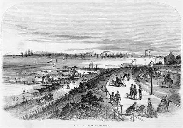
But the previous year, a large trading ship had arrived in Melbourne and had anchored south of the city, directly adjacent to the proposed site of the new village. The name of this vessel; 'The Lady of St Kilda.' The ship anchored in Melbourne for some months and dominated the largely undeveloped shoreline to such an extent that the area was soon referred to locally  as 'The St Kilda foreshore.'

The Lady of St Kilda, at anchor.
The story goes that Governor La Trobe, attending a picnic in the area in 1842 and having consumed some champagne, decided then and there that the new village would be called St Kilda, after the ship. This was soon officially proclaimed and the land sale went ahead as planned towards the end of 1842.


The Lady of St Kilda  depicted on a contemporary rail bridge.

The first purchaser was James Ross Lawrence, who had been the master mate on the Lady of St Kilda. Allowed to name the street that fronted his block of land, Lawrence chose Acland Street, after Sir Thomas Acland, the ship's original owner.


St Kilda in 1864, shortly after its founding.

So if the suburb is named after a boat, where then did this craft take it's name from?

The Lady of St Kilda was a schooner, built in Devon in 1834 for Acland and used by him as part of his trading business (initially bringing fruit from the Mediterranean to England). Acland named the ship after a visit his wife Lydia had paid the St Kilda archipelago, part of the Outer Hebrides Islands off the coast of Scotland, for a holiday in 1810.


Although the lady of the ship's name is not Lydia herself but Lady Grange, a famous prisoner once kept on Hirta, the main island of the St Kilda group.

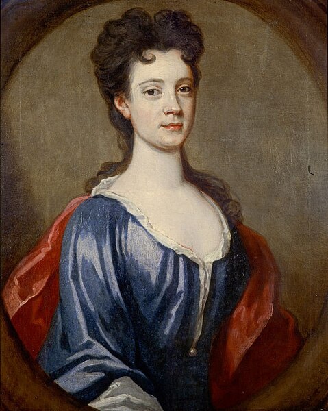
Lady Grange was the wife of James Erskine, a wealthy 18th century Scottish lord and barrister. In 1732, the good lady discovered papers that showed her husband was involved in a plot to overthrow the British monarchy. The plot was part of an ultimately failed coup attempt designed to install Scottish heir Bonnie Prince Billy on the British throne. Outraged by this treasonous behaviour, Lady Grange immediately determined to reveal her husband's activities. But Erskine was alerted to his wife's maneuver and struck first.


Rachael Chiesley, AKA Lady Grange

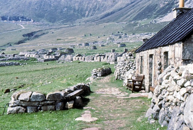
Lady Grange was abducted at her husband's order and taken initially to an isolated castle that he owned in northern Scotland. She was then interred in a private mental hospital before being moved to the St Kilda islands around 1735. Now imprisoned in one of the most isolated inhabited spots on Earth, the noblewoman endured years of degrading treatment; living alone in a stone dwelling with an earthen floor, among a small local population who spoke no English, suffering poor health due to the island's harsh climate and lifestyle.


Barren, windswept, primitive; a village street on Hirta
She would remain on Hirta until about 1740, when she was finally able to smuggle a message to her supporters on the mainland begging for rescue. An armed rescue party was raised, but by the time it reached Hirta, Lady Grange had been removed and taken elsewhere. She died, still in her husbands captivity, in 1745.

Acland then, had had his attention brought to St Kilda by his wife's visit, and had named his ship as tribute to this long suffering British patriot.

But what of the islands themselves? Where did they take their name from? What is the root of the name 'St Kilda'?

While opinions differ, the most widely accepted theory has this as a simple translation error. The first settlers of the islands were Norse, and some histories show the name of the islands recorded as Skildir, an old Norse word meaning 'shield.' This has been mis-recorded on a Dutch map from 1583, which has the name as Skildar. These same charts were revised and updated by the Dutch Government in 1592, Skildar now being misrecorded as S.Kilda. This type of error was common at the time, due to human error and the primitive means available for recording printed information.

As the Dutch were among the foremost seafarers of this time period, and among the furthest travelled, many other countries would base their own official charts on those of the Dutch. British chart makers who used this 1592 map as the basis for their own work, simply assumed that S.Kilda was a shorthand way of recording St Kilda, and recorded it as such themselves.

And so a previously unrecorded Saint was summoned into existance, which 250 years later would find it's way into the name of one of Melbourne's beachside suburbs. The last of Hirta's population left the islands in 1930, the St Kilda islands are now a UNESCO listed World Heritage Site.


Wednesday, April 17, 2013

The Paris End of Melbourne


So why is the Eastern end of the Melbourne, particularly Collins Street, referred to as 'The Paris End'? It's a great nickname, and one you hear a lot, yet you have to wonder where it came from.

What is especially Parisian about this part of the city? It's architecture and general design aren't particularly reminiscent of the City of Light, and Paris' famous arts and cultural trappings aren't mirrored here either, as they are in some other parts of Melbourne. Nor is there any direct link between the two cities; they aren't sisters and no famous French exiles came and settled here.

In fact, the answer is to be found in the lifespan of a hotel that used to stand at the top of Collins Street, and a lengthy debate that revolved around the footpath in front of it.

The southern block of Collins Street between Exhibition and Spring, where the gargantuan Collins Place now stands, was home to a hotel for most of Melbourne's first hundred years. The first of them, The Bedford, was built in 1854 and offered a standard saloon and basic accommodation.

This was replaced by the more elaborate Oriental Hotel, which was erected in 1878 and became a favourite of Victoria's landed gentry. During the boom of the 1880's, the Oriental was figured to be one of Melbourne's finest establishments, particularly well known for the quality of its food and drink.


The Oriental Hotel, circa 1894


Pearson Tewksbury, one of the many patrons of the Oriental who had made his fortune in the gold rush, was so taken by the place that he moved into it with his wife, when they relocated to Melbourne from his country estate in 1910. After a year as a resident, Tewksbury had a falling out with the hotel's manager, who requested that he find lodgings elsewhere. Rather than move, Tewksbury bought the hotel outright, and instructed the manager to find work elsewhere.

A well traveled  and energetic, man, Tewksbury had grand plans for his new acquisition. He bought and demolished the building next door, a private residence, to provide space for a new wing for the Oriental, which was furbished in the most modern style. He also acquired space at the rear of the property where he established the City Motor Service, a fleet of chauffeur driven cars for the use of hotel guests. The motor service soon proved so popular that it was made available to the general public and this gradually turned, over a number of years, into Melbourne's first taxi cab fleet.


A well traveled man; Pearson Tewksbury


Tewksbury also built a combined cafe and restaurant on the hotel's ground floor, and had an idea for the footpath out the front of it. Having traveled extensively through Europe, Tewksbury had been impressed by the sidewalk cafes he had seen in operation in many European cities. Melbourne's mild, but pleasant, summer seemed like the ideal climate for such a cafe, an idea that was entirely unknown in Melbourne, and indeed Australia, at the time.

In 1933, Tewksbury lodged a formal request with Melbourne City Council to allow dining on the Oriental's footpath. The council turned him down flat, indicating that they felt a footpath cafe would disrupt pedestrian traffic. It probably didn't help that one of the city Councillors had grown up in the house that Tewksbury had demolished to expand the Oriental, although an opinion piece in The Age expressed bemusement that such a simple idea had been prohibited:


Column in 'The Age,' May 29, 1933


Either side of World War Two, Tewksbury continued to refashion the Oriental, often co-opting new design and decoration ideas he had seen in America. In the early 1950's, he decided to completely rebuild the premises from top to bottom, but passed away before he could get this project underway. The hotel was then purchased by Leon Ress, a successful hotelier with a number of local properties in his portfolio.

Ress had ideas for the redevelopment of the Oriental as well, and he oversaw a considerable modernisation of the hotel before the 1956 Olympics. As well as updating the suites and public areas, Ress also revamped the hotel's dining facilities. Part of this involved reviving Tewksbury's old idea for a sidewalk cafe.
Ress' wife was originally from Paris, and she thought the broad footpath frontage perfect for a series of tables and chairs, much as she was familiar with from her native city.

This time the proposal was approved, doubtless assisted by Leon Ress' presence on the city council. The Oriental would be allowed to place nineteen tables on their footpath for a three month trial period (although the service of liquor would be prohibited outside).


Images of the Oriental footpath cafe in operation, all from 1958.


The new, cosmopolitan cafe created quite a stir in Melbourne; locals flocked to the Oriental to try it out, while the press coverage was voluminous.

Mrs Ress enthused to local journalists: 'This is wonderful. It is just like the Champ Elysees back in Paris.'

And this widely reported remark gives us our answer: The 'Paris end' of Melbourne was coined and it simply stuck in the popular imagination.

The phrase proved more enduring then the cafe that spawned it. Despite its popularity and prominence in the city - it was used in a number of tourist ads promoting Melbourne - the footpath cafe lasted only two years before being forced to close. The local police were responsible, claiming that the cafe restricted both pedestrian and street traffic. After some back and forth with the city council, now firmly in favour of the idea as it attracted business to the city, the police had their way and the cafe was closed:


'The Age,' January 7 1960, a few weeks before the cafe would close for good.


The Oriental itself didn't last very much longer, demolished in 1972 as part of a block leveling exercise that made way for Collins Place. But it's worth remembering its place in history, whenever you overhear someone remark that they 'work up the Paris end of town.'

Sunday, January 27, 2013

The Three Brunswicks


In the inner city of Melbourne, there are three Brunswicks.

The suburb of Brunswick; north of the city and currently undergoing a rapid makeover from solid working class to rampant hipster kingdom. Brunswick Street; the main thoroughfare through Fitzroy, a suburb that made this same transition some time ago. And Brunswick Road; running perpendicular to, and between, both.

The origin of the name 'Brunswick,' as used in these Melbourne places, is no longer clear. It seems fitting that, as there are three places bearing the name, there are also three possible explanations as to how it became attached. It is even possible that there are different explanations for each.

But the suburb of Brunswick was the first of the three to appear in Melbourne, making it likely that the roads were named after it.

Surveyor General Robert Hoddle assessed the area that would become the suburb in 1839 and determined that it was fit for settlement. A broad, rough rectangle of land would be offered for sale, the boundaries of which would be; the newly created Moreland Road to the north, Park Street to the south and Moonee Ponds Creek and Merri Creek to either side. Connecting Moreland Road and Park Street, a narrow road would be built approximately in the middle of the newly designated area, originally called Pentridge Road, and later renamed Sydney Road once it became the chief route out of Melbourne to the north.

The survey plan for the new suburb from 1839. The two creeks are visible at
either end of the division, with numbered lots of land in between.

The land on either side of Pentridge Road was divided into eleven equal sections, each piece running from the road back to the relevant creek (depending on the side). Such was the simple, efficient way that most of early Melbourne was laid out.

Much of the early land sold in this, still unnamed, area went to land speculators, investors with an eye on the future. Melbourne was still small in 1840 when the new land was offered for sale, and the freshly subdivided area 5 miles from the township was not much in demand. But  a few hardy types bought and settled on the properties straight away. One of these was Thomas Wilkinson.

Wilkinson was born in Sunderland County, in England, in 1799 and emigrated to Van Dieman's land in 1833. He worked in Launceston initially, in service of the convicts there and providing religious and moral instruction. This was followed by a short stint on Flinders Island, providing similar services to the local Indigenous population.


Drawing of Thomas Wilkinson, date unknown.

Looking to establish himself, he moved to Melbourne in 1840 in search of fresh opportunities. Wilkinson took a job as a law clerk and within a year had saved a sufficient sum to allow him to buy (in partnership with his friend Edward Parker) one of the new parcels of land north of the city. Wilkinson built himself a small house on the corner of Albert Street and Sydney Road and so became one of the first residents of the new district.

Wilkinson called his new property 'Brunswick.' There are two theories as to why he did this.

The most widely accepted of these is that the name was chosen in honour of Queen Caroline, late wife of King George IV of England.

Portrait of Caroline by James Lonsdale, 1820

Caroline was born Princess Caroline of Brunswick, a region in Northern Germany near Hannover. The German root of the word Brunswick is a combination of two other words; 'Bruno', the eleventh century conqueror of the region, and 'wik,' a German word meaning meeting place. So the area was named after the town Bruno established, which immediately became the central meeting and trading point for the region.

Caroline married George, Prince of Wales, in 1795. It was a loveless arranged marriage, designed for political reasons, and the pair started to live separately after Caroline gave birth to a daughter, Charlotte, in 1796. Both Prince and Princess likely took lovers and had little to do with each other. Caroline left England in 1814 and lived in Italy for a time, returning only in 1820 when George ascended to the throne.

But George was not happy to see his consort return, and immediately began agitating for divorce. As well as the entrenched dislike between the two, George was an unpopular, authoritarian King and Caroline had been installedby the public as the figurehead for a burgeoning reform movement. Caroline was publicly accused of adultery and Parliament set to investigating her fidelity.

The Trial of Queen Caroline, by Sir George Hayter.

Even while accused of, what was at the time, a serious criminal offence, Caroline remained popular with the masses. 800 petitions with more than a million signatures in support of her were lodged during her trial. The House of Lords, charged with the preliminary investigation, found her guilty of an affair with an Italian servant, but their findings were never passed on to the House of Commons for ratification. It was assumed that Caroline's popularity would have ensured their defeat in that house.

Furious that his will was not carried out, George excluded Caroline from his coronation ceremony at Westminster Abbey. When she tried to attend, her way was blocked several times by soldiers loyal to George. Shortly afterward, Caroline became seriously ill and deteriorated steadily over the next few weeks. She died on 7 August 1821, aged 53, and was buried in her native Brunswick. Her exact cause of death is unknown and speculation ranges from cancer to poisoning at the hands of George's agents. Caroline's sudden death caused some disturbances in England and further entrenched George's unpopularity with sections of his people.

A young Thomas Wilkinson lived through this period of English history and undoubtedly Caroline's tragic story would have had an impact on him, as it did many others at the time. So it is believed that he named his new property on the other side of the world as a small tribute to the late Queen Consort.

But other theories have been floated as well.

The second of these also relates to royal goings on in England. After the death of George IV, Queen Victoria ascended the throne in 1837. In 1840 she married Prince Albert and there is some thought that Brunswick was named after the Prince's German royal house. This appears on several websites I have seen, as well as in  the official written history of Brunswick, commissioned by the Moreland Shire Council (Brunswick: One History, Many Voices, edited by Helen Penrose).


Victoria and Albert in 1840.

But in regards to this idea we can be certain; Brunswick is not named after Prince Albert, as he was from the German house of Saxe-Coburg. Although it is worth adding that the first two streets in the new area, Albert Street and Victoria Street, running at ninety degrees from Pentridge Road, were named after the newly married royal couple. News of their nuptials would have reached Australia just as the suburb was being sketched out and divided (the south Melbourne suburb of Albert Park is also named after the Prince).

The third possibility for Brunswick's naming comes from the VICNAMES website, an official Government body that maintains a database of Victoria's place and street name origins. The entry for Brunswick reads:

Named after Captain George Brunswick Smyth, 50th regiment. He was in charge of mounted (military) police in Port Philip, 1839.

This explanation also appears on the Yarra Council website, in their own list of name origins, for Brunswick Street and so is not easily dismissed. But how or why this police captain would have got his name attached to a new suburb is unclear. Another landholder in the region, a neighbour of Wilkinson's, named WFA Rucker was known to have been a friend of Smyth's, and there is speculation that Rucker may have adopted the name of his friend for the new area.

But hard evidence of this has remained elusive. Acknowledging this theory in Brunswick: One History, Many Voices, Gillian Sansom writes that the oldest records the council has show the name Brunswick attached only to Wilkinson's property, not Rucker's. The council seem certain as to their preferred theory of the name origin, as their historical marker on Albert Street indicates:


In any case, Wilkinson attached the name Brunswick only to his farm, which was one among many in the new area. How did it come to be adopted by the suburb as a whole?

Tom Wilkinson was an industrious man; hard working and talented in a variety of areas. The small house that he built for himself doubled as the area's first church and post office, and he oversaw and helped finance permanent, purpose built, replacements for both. He also leased the first land used by shopkeepers along Pentridge Road and Albert Street, which dramatically increased the economic viability of the area. And he started, and for a time edited, the new suburbs first newspaper. He dominated the region to such an extent that it was only a short progression for people to start referring to the whole district by the name attached to Wilkinson's farm.

So it seems reasonably certain that Brunswick, the suburb, was named after Princess Caroline and that the two nearby streets with the same name were named after the suburb. Brunswick Road as it ran close to the southern boundary of the area, and Brunswick Street as it would have been a major route North from the city towards Brunswick at the time it was built.

A sketch of Brunswick St by Sarah Bunbury, 1841.

One final trivial footnote on the Origin of the name Brunswick. In 1914, after the declaration of war by England against Germany, the North Brunswick Progress Association lobbied the local council to change the name of the area, complaining about that they did not want to reside in a suburb with a German name. The council's respsonse is not recorded.